Date Climbed: 4/29/2012
Peak: Mt. Whitney (14, 501')
Route: Mountaineers Route- Class 3/4
Gear: ice axe, crampons, helmet
 |
| The Mountaineers Route |
A quick route description:
Approach- Starting at the Whitney Portal Trailhead, follow long sweeping switch backs to a sign near a small waterfall that marks the way to the Whitney Trail.
 |
| Turn north here |
Turn right up the hill and follow trail through dense trees. Once the trail comes out of the trees, there will be a large sandy clearing. look to the left for the trail to continue behind a fallen tree. This will then take you across to the south side of the creek. Stay on the south side of the creek(more pertinent in the winter) until the trail drops back down into the willows surrounding the creek. (In the winter it is also possible to stay on the south side of the creek all the way to Lower Boyscout). Once you cross the creek back to the north, turn west and follow through a tight clearing in the willows right up against the cliffs that make up the Ebersbacher Ledges. You will know when you are at the base of the ledges when you see obvious class 3 terrain in the form of boulders and steps. There is also an obvious tree about 50ft up the class 3. A lot of people may be nervous of what the ledges have to hold, but as long as you stay on route the exposure and difficulty are very low(there are no narrow ledge systems on route). The ledges soon turn into another winding trail system and before long you are at Lower Boyscout Lake.
 |
On the talus above LBL
The lake offers some good camping options if you are not in a rush. Stay to the left side of the lake, the trail skirts the slope just above the lake and heads up through and obvious talus field to the southwest. Once at the top of the talus field follow the trail through the brush and onto the slabs. Once on the slabs follow the cairns all the way to Upper Boyscout (In the winter you can slog across the open field).
|
 |
| The shrubs on the way to the slab and UBL |
 |
| UBL and Mt. Russel in the background |
Upper Boyscout Lake also offers some camping options but not quite as many as Lower Boyscout and it seems the wind gets funneled though there from Mt. Russell. A better option in my opinion is to continue up the use trail to the south and follow it to a small rock outcrop on the left. The south side of this outcrop offers good flat wind protected ground to camp on. From here continue up the trail to near the base of Whitney's east face.
 |
| First peek of Whitney since the trailhead |
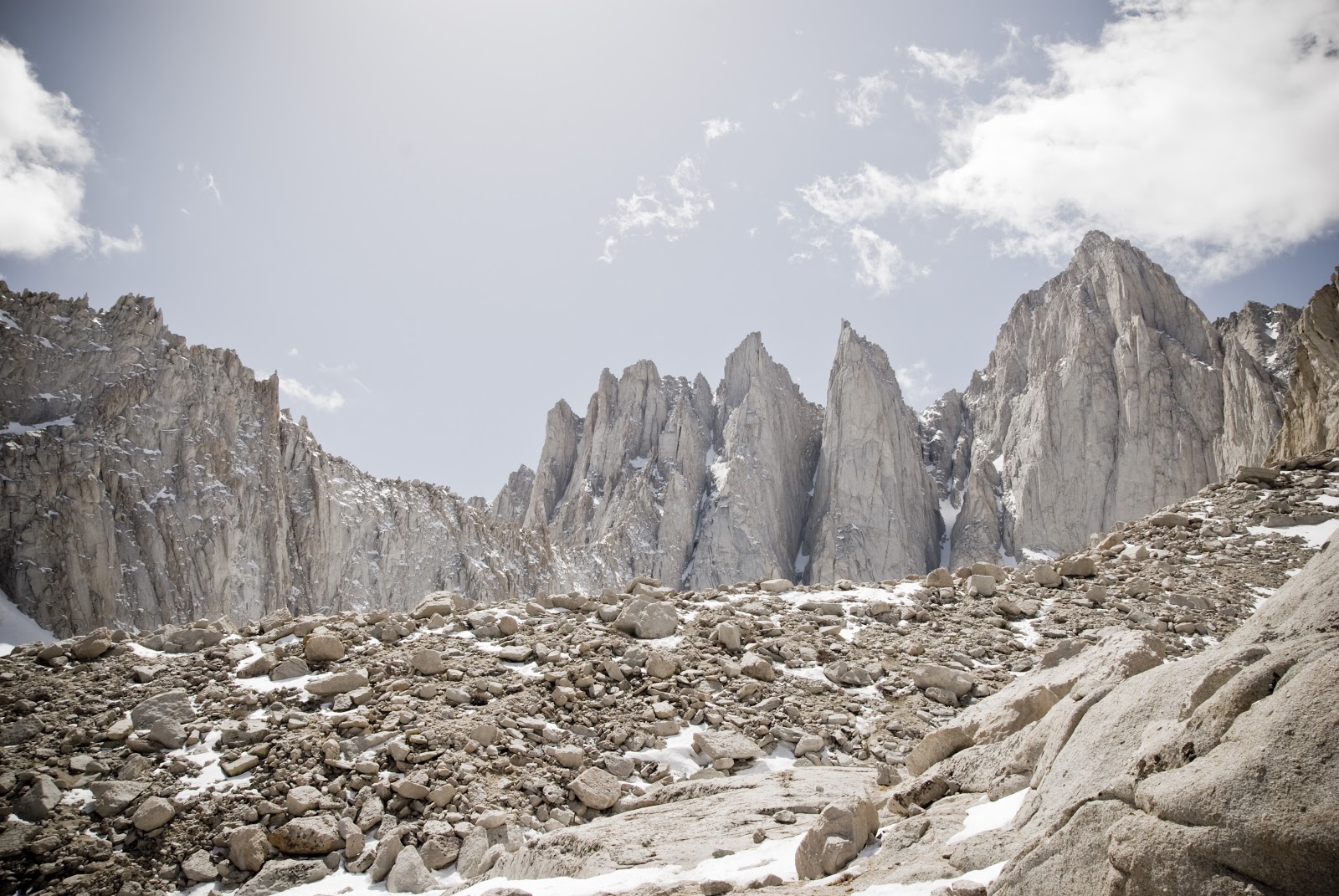
The cairns here are good and finding the way up to Iceberg Lake should not be an issue. Once at Iceberg Lake many options for camping exist though few are protected. This offers the best views of Whitney and in my opinion the best experience as well.
 |
| The Iceberg Plateau and Mt. Russell |
The Route- Walk across the Iceberg Lake plateau to the base of the obvious couloir that is the Mountaineer's route.
 |
| Midway up the main couloir |
Follow couloir to the notch and crest the notch and continue down 20 feet or so. From here you have a choice, the steepest class 3/4( best option in my opinion) immediately on your left, slightly less steep a few hundred feet further on the left, or the 3rd class option which contours to the west until the western slope is reached. The first is the most classic.
When I first got the itch to become a mountaineer, I stumbled upon a picture of Mt. Whitney and its Mountaineer's Route. Back then it looked impossible. The couloir shot straight out of the terrain and the route just disappeared behind the mountains east face. It was so aesthetically pleasing, even to someone with no experience whatsoever. This combined with Whitney's claim to fame, makes the Mountaineer's route one of the most popular routes in the world. I knew that I had to do it.

It was not until 3 years later that I would get my first chance to try the route. A friend and I had just climbed the Baldy Bowl a week prior and we wanted something a bit more challenging so we set our sights on Whitney. It was the middle of December in the snowiest winter the Sierras have ever seen. Knowing of a recent 15 foot dump of snow the week prior we decided to test our luck. We drove up on a Thursday evening and parked at the usual road closure on the portal road. From there we hiked up the road with snowshoes, passing multiple cars trapped by the sudden storm. We finally decided to set up camp right on the road a few hundred yards ahead of the Whitney portal. That night it was cold. Really cold. The temperature in the tent got down to 3 degrees F. Both of us had frozen boots. It took us quite a while to get going in the cold. I could not seem to get my hands or my toes to warm up. By the time we started for the trailhead we were already defeated, and after a few hundred yards and deepening snow, we turned around and went down. We later found out that it was two weeks before someone broke through, but they still did not summit.

My next chance to climb the route came in March of 2012. My friend Scott and had been training for Rainier. Scott had done the East Buttress of Whitney before and had no real interest in the Mountaineer's Route, but Rainier beckoned and we both needed the training. This time the snow was a non issue, 2012 was a terrible snow year in the Sierras. However when we got to our camp at Upper Boyscout Lake we realized that we had forgotten a source of fire for the stove. We went to bed hungry with cold water. The next morning we both felt a bit drained having not replenished our bodies. We both decided that a summit attempt was out of the question, but a quick 30 min. jaunt a bit higher to catch a view of the mountain was in order. After a viewing session we packed up and headed out, determined to return more prepared.
 |
| Scott just after the trail split |
It was a month later, on the verge of permitting season, that I finally had a successful attempt. Again, Scott and I, fresh off a successful ascent of Snow Creek on Mt. San Jacinto(by far more difficult), set off up the 395 at night, on the way to Lone Pine. We slept in our car the best we could, and lighter packed we set off the next morning. This time we decided it would be better to go all the way to Iceberg lake to have an easier summit day. This was fine with me, but Scott was worried since he suffers from debilitating altitude sickness occasionally.
 |
| Mtn Harwear EV2 and Mt. Russell |
In my infinite wisdom I chose to take a minimalist approach on this trip and only brought a 35 degree Mtn Hardwear UltraLamina and a +15 degree liner. The forecast was for 20 degrees. No surprise I was freezing all night even wearing all of my clothes. This wasn't the first time I had done this either. You would think I would learn. I guess a part of me likes the suffering. Well after a bad night sleep for both me and Scott, which more often than not is the case, we made some breakfast and then set off up the route about 30 min. after sunrise. The snow was decent at the start but was quickly softening in the morning sun. We hurried up the couloir which by this time of year was part rock part snow. It was not till the last quarter of the couloir that it was mostly all rock and dirt. We took a short break at the top of the notch to pack away ice axes and crampons and eat a bar. We then descended the 20 ft to the base of the top section. It was half rock and half snow/ice. There where two teams roped up. We had no rope. This worried us slightly but it appeared a route through the rock could be managed and we opted to go cramponless. We climbed some class 3/4 slabs dotted with ice to a nice ledge. Scott decided to throw the crampons back on for a short traverse across the snow. I decided to just take it really slow. It was pretty nerve racking walking across the small snow walkway with now crampons, looking down the north face to some lakes 3000ft below. I sucked it up and kept my balance and after 10 feet was safely to more class 3 rock. Once on the right side of this chute the climbing is pretty easy with maybe 1 or 2 class 4 moves. The snow and ice made it a bit more dicey but it was easily managed. Before we knew it were were at the top of the chute a few hundred yards from the summit.
 |
| Scott taking a quick break mid way up the couloir |
 |
| Finally on the summit of Whitney(Russell looks tiny) |
We scrambled the class 2 talus to the true summit where we celebrated with a few photos and another small snack. For me it was great to finally climbed and summited something that had possessed my thoughts for so long. We decided to take the less technical class 3 contour back to the notch. This was actually very exposed in places and one slip would result in a desperate self arrest situation. Looked great for skiing though. Once back at the notch we quickly made our way down the deteriorating snow to our tent. Round trip tent to tent was in the 2 1/2 hour range. It took us another 4 hours to hike out. Great route. Next I'd like to try the East Buttress.
 |
| The Iceberg Abyss |
More Pictures:
 |
| LB Meadow |
 |
| Scott resting on talus field above LBL |
 |
| Water streaks above LBL |
 |
| UBL |
 |
| Crooks, Keeler, and Whitney |
 |
| Me in the couloir |
 |
| Scott enjoying the summit |
 |
| Looking north to Russell and Williamson |
 |
| Scotts Summit pic |
 |
| Headache |
 |
| Is this really the Sierras? |


 It was not until 3 years later that I would get my first chance to try the route. A friend and I had just climbed the Baldy Bowl a week prior and we wanted something a bit more challenging so we set our sights on Whitney. It was the middle of December in the snowiest winter the Sierras have ever seen. Knowing of a recent 15 foot dump of snow the week prior we decided to test our luck. We drove up on a Thursday evening and parked at the usual road closure on the portal road. From there we hiked up the road with snowshoes, passing multiple cars trapped by the sudden storm. We finally decided to set up camp right on the road a few hundred yards ahead of the Whitney portal. That night it was cold. Really cold. The temperature in the tent got down to 3 degrees F. Both of us had frozen boots. It took us quite a while to get going in the cold. I could not seem to get my hands or my toes to warm up. By the time we started for the trailhead we were already defeated, and after a few hundred yards and deepening snow, we turned around and went down. We later found out that it was two weeks before someone broke through, but they still did not summit.
 My next chance to climb the route came in March of 2012. My friend Scott and had been training for Rainier. Scott had done the East Buttress of Whitney before and had no real interest in the Mountaineer's Route, but Rainier beckoned and we both needed the training. This time the snow was a non issue, 2012 was a terrible snow year in the Sierras. However when we got to our camp at Upper Boyscout Lake we realized that we had forgotten a source of fire for the stove. We went to bed hungry with cold water. The next morning we both felt a bit drained having not replenished our bodies. We both decided that a summit attempt was out of the question, but a quick 30 min. jaunt a bit higher to catch a view of the mountain was in order. After a viewing session we packed up and headed out, determined to return more prepared.


No comments:
Post a Comment