Date Climbed: Early April 2012
Peak: Mt. San Jacinto (10,834')
Route: Snow Creek- Grade IV Class 4/5.7 WI 1 Moderate Snow
Gear: Helmet, Crampons, Ice Axe, (rope and a few nuts could be helpful)
Disclaimer (sort of):
This was one daunting climb. Plagued with access issues, poor snow, and difficult route finding, its not recommended for the beginner. With regards to access, be sure to research the Desert Water Agency's rules on the area. There is a one square mile plot of land that must be avoided. Lets keep this jewel open for others in the future.
 |
| A rough route |
To help train for our May trip to Mt. Rainier, Scott and I decided that the time was right for a trip up the Snow Creek route on Mt. San Jacinto. This route is by far the most difficult in Southern California, and easily one of the best alpine routes in the country. However, there is not much in the way of information about this route. There is no trail, there are hardly any cairns. This is a true mountain route that requires a complete knowledge of backcountry travel and route finding. Anyways. We drove from our home in Orange County out to Palm springs in the early morning hours. We arrived at the pullout of the road right at sunrise.
 |
| Nervous |
 |
| The DWA land |
Twenty minutes later we set off across the desert unsure of where we were going and how long it would take us. We wove our way through the brush until we reached the base of the ridge that is used to skirt the private property. Just a few years ago, the common practice was to try and cross the private property in the early A.M. hours. Now you are guaranteed to be caught and fined. Climbing up the slope below the ridge was loose and complicated. There was a lot of shrubbery to be avoided and the threat of rattlesnakes always loomed in the back of our minds. We had read other trip reports where people had gained the ridge and taken it all the way passed the private land and then dropped back down into the drainage for a huge elevation loss. We decided to try and avoid that and just contour the slope just above the DWA land. The process was slow. Sometimes it would cliff out. In the end we found out that this way was more of a pain than we had hoped. We finally dropped back down to the left fork of the creek about a quarter mile after the waterfall.
 |
| The left fork of Snow Creek |
 |
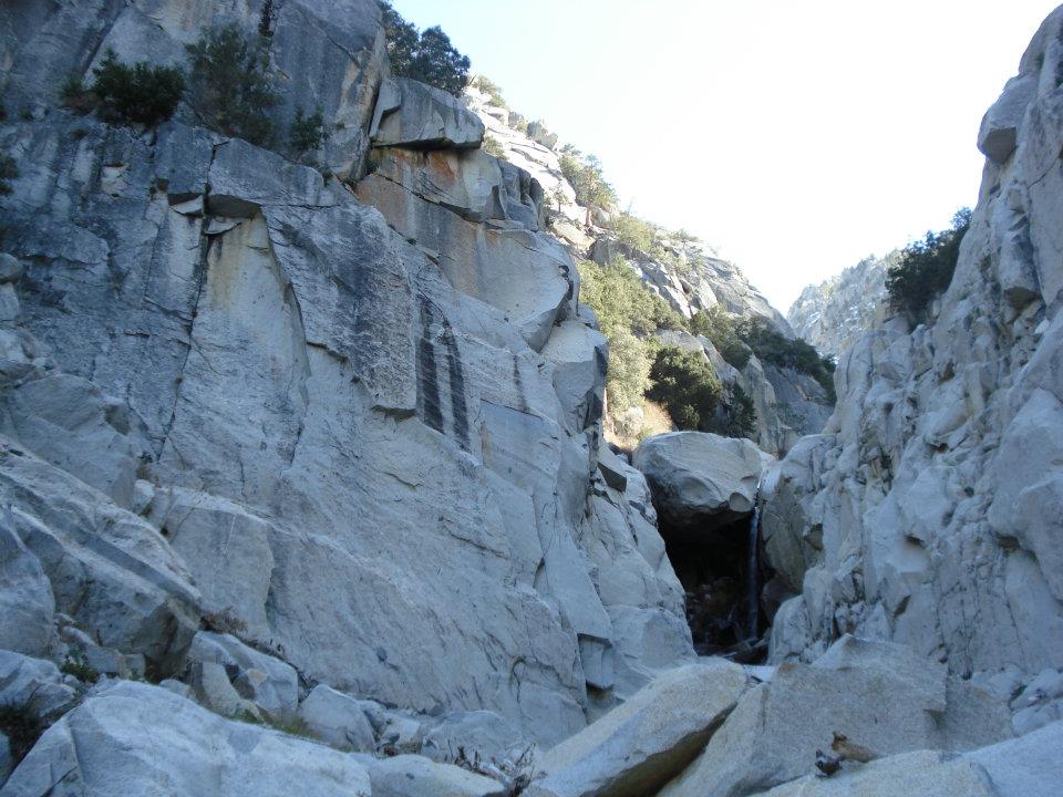
| Waterfall just above Scott's head |
The creek offered some welcomed shade from the desert sun, but our enjoyment was ended by the rattle of a very pissed off snake. Scott had disturbed him when he stepped over a fallen tree. I still had to make it passed this tree as well and there was no way around. I bit nervous and ran and jumped over it in hopes I would be moving to fast for the snake to strike. Luckily I succeeded. From then on we were very cautious of where we stepped and where we placed our hands. We scrambled up the other side of the creek onto this sort of plateau that is in between both forks of the creek. From here we thought we could see a faint use trail here and there, but it seemed to fade in and out. Every once in a while we would randomly stumble upon a cairn. Our technique was to just use the path of least resistance(more rock, less bushes). It seemed to do the trick because all of a sudden out of nowhere we came upon this tunnel through the shrubs. From a highpoint we realized that this seemed to be the only way through the dense vegetation without a machete. So we were lucky that we found it. By this time we had been in the hot desert sun for 5 hours and we were out of water. After the shrub tunnel, and some steep loose terrain, we found a small creek, and filled up our water bottles. From here the route stays left of the creek proper and continues up a small gully that looks like it will cliff out above the creek. Just keep going this is the right way. Scott and I were getting pretty beat down from all the bushwhacking, so when we crested the gully and found a small trail into the creek proper we felt a bit rejuvenated and relieved.
 |
| The point of relief |
 |
| The Chockstone, 4th class terrain on right just out of frame |
Once in Snow Creek itself the terrain depends solely on the amount of snowfall. If there is a lot of snow, the whole couloir can be filled with snow and avalanche debris. We were unfortunate and found there to be no snow at the start of the route. We boulder hopped up until we came to the Chockstone, a key marker on the route. In high snow years it can be completely covered. In our case it was completely dry and we had to take the 4th class ledges on the right. I could have sworn the top move was in the low 5th class range, especially in mountaineering boots and with a large pack. The use trail then takes you winding through small trees for a few hundred vertical feet. On the way through the trees, two climbers came down, one of them covered in blood. We asked what had happened and if they needed help. The hurt climber said that he was fine is was just a cut. Apparently they had gotten off route and climbed the wrong gully up a peaklet. Near the top of the peaklet it began to cliff out on them so they retreated and the climber fell and cut his hand. This made us pretty nervous. We wondered if we could find the right way. We wished them luck on the bushwhack back out and continued up through the trees. We exited the trees above a gully and were greeted with our first real glimpse of the route.
 |
| Our glimpse of the route |
From there we tried to contemplate where the other two had gone wrong and tried to scope out the best route through the multiple steps. We descended into the gully and a few hundred feet up the creek later we found a nice flat spot to put our sleeping bags. While unpacking we realized that we had forgotten fuel for our stove. We couldn't believe it. A few weeks before we had forgotten a lighter on Whitney. (checklists are a good idea) We opted to rehydrate our food with cold water. It wasn't to cold outside so this was tolerable. We sat around and studied the map a bit more before we went to bed. It was still pretty early but the steepness of the canyon made it pretty dark.
 |
| Scott at one of the first rock steps |
The next morning we stayed in our sleeping bags till the sun rose and a faint amount of light entered the canyon. We packed everything up since we would not be coming back down the same way. Crampons, ice axe, and helmet ready to go, we began the climb. At first it was a mix of low angle snow and some boulder hopping. Then there was a short 10ft frozen waterfall, I would rate at WI1 or neglegable. We continued up some more snow and then we were hit with cliffs on all sides. We weren't sure what to do. The easiest way seemed to go the wrong way(this is where the other two got lost) We tried the next point of weakness. About 20 ft up we realized it was far to loose to safely climb so we backed down that as well. The only other viable option was a 25ft solid headwall. There was a small trough running up through it that looked like it could be climbed, but when we looked at it closely, it didn't look as easy. We decided to just climb the face itself. Luckily this could be done in two chunks. Scott went first and it didn't look easy. I handed him his pack and mine as well then I tried it. It was only 3 or 4 moves, but they were easily in the 5.7 range. It required smearing in bulky boots while only being able to grab sloppy oddly angled holds. Needless to say it scared the crap out of me. The second half wasn't as technical but it was just as scary since a fall would be very serious. Luckily we both made it to the top fine, and were relieved to see that it was snow the rest of the way.
 |
| Scott just above the free solo |
 |
| Me just after the first fork |
 |
| Nearing the second fork |
 |
| Me headed up to the last fork |
 |
The right of the left forks (there are two take the one on the right)
|
 |
| The last few soggy feet |
 |
| Looking down the route |
 |
| Success! |
From that point the snow got steadily steeper. Nothing over 50 degrees though. The upper part of the mountain can be pretty confusing. The way I remember it is that at the first fork stay right, at the next fork stay right, and at the third go left. By the time we were almost near the top the snow had gotten super soft and the microwave effect from the canyon and the snow put the temperature around 90 degrees. We were cooking. We stopped once or twice in some shade to catch a break from the sun, but we knew the snow would just get more unstable. We pressed on and near the top we encountered the steepest climbing. In the loose snow it required all four limbs to get up it. We stood on top a few minutes later. We talked to a nice couple for a few minutes and they offered us some of their sandwiches which we accepted graciously even though I'm vegan and their ham and cheese wasn't. We could tell that they really wanted to help us and that they really didn't want their sandwiches. They took a picture for us and then we raced off down the main trail to get back to the tramway. On the way down we tried to make a b-line through the woods. Soon we got pretty worried that we might get lost because the forest was so dense and we couldn't see any landmarks that would be visible on the map. We decided to just continue in the same direction. Eventually we came upon some areas I recognized from when I came bouldering. In the end it only took us an hour or so to hike back to the tramway. Once at the bottom, Scott's dad was nice enough to pick us up and take us back to the car. At the end I checked my altimeter watch and it said that we had done a total of 13920 ft. of elevation gain over the two day climb. And according to the map it was roughly 20 miles of distance. "I think we are ready for Rainier."


No comments:
Post a Comment